Sunday, May 27, 2012

Selecting a trail route before construction WWFF-07

Routes and Layouts


Some trails lead to specific sites or vistas. If there is a very specific place hikers want to see, there should be a trail going there. A waterfall, Indian Mound, old homestead, or bird viewing blind are examples of specific destinations.
    There was no "Official" trail to this view, but there was a volunteer path to it, interrupted by the sign below. For twice the price of the sign, a boardwalk could have been put in to avoid damage to the mangrove root, and an ugly, rude sign would not have been needed.

If a designated trail does not go where people want to go, odds are that an unofficial trail will pop up anyway.

 If there is a trail that takes a circuitous route to that site, a map should be posted showing the trail route. To prevent volunteer trails, or braiding of trails, managers often use boardwalks with waist high handrails to keep people on the designated route. Signs and fencing are less friendly ways to keep people on trails, but are less expensive alternatives to a boardwalk.


When designing the trail routing, it is important to keep sight distances at 100 feet or less to draw the hikers view, and attention to the near field. Gentle curves and turns keep the user focused on the views and not the trail ahead. The one exception is a fitness trail, that needs long straight sections for runners and bicyclists. This lets the runners and cyclist see other users and obstructions with time to avoid collisions or prevent startling surprises.

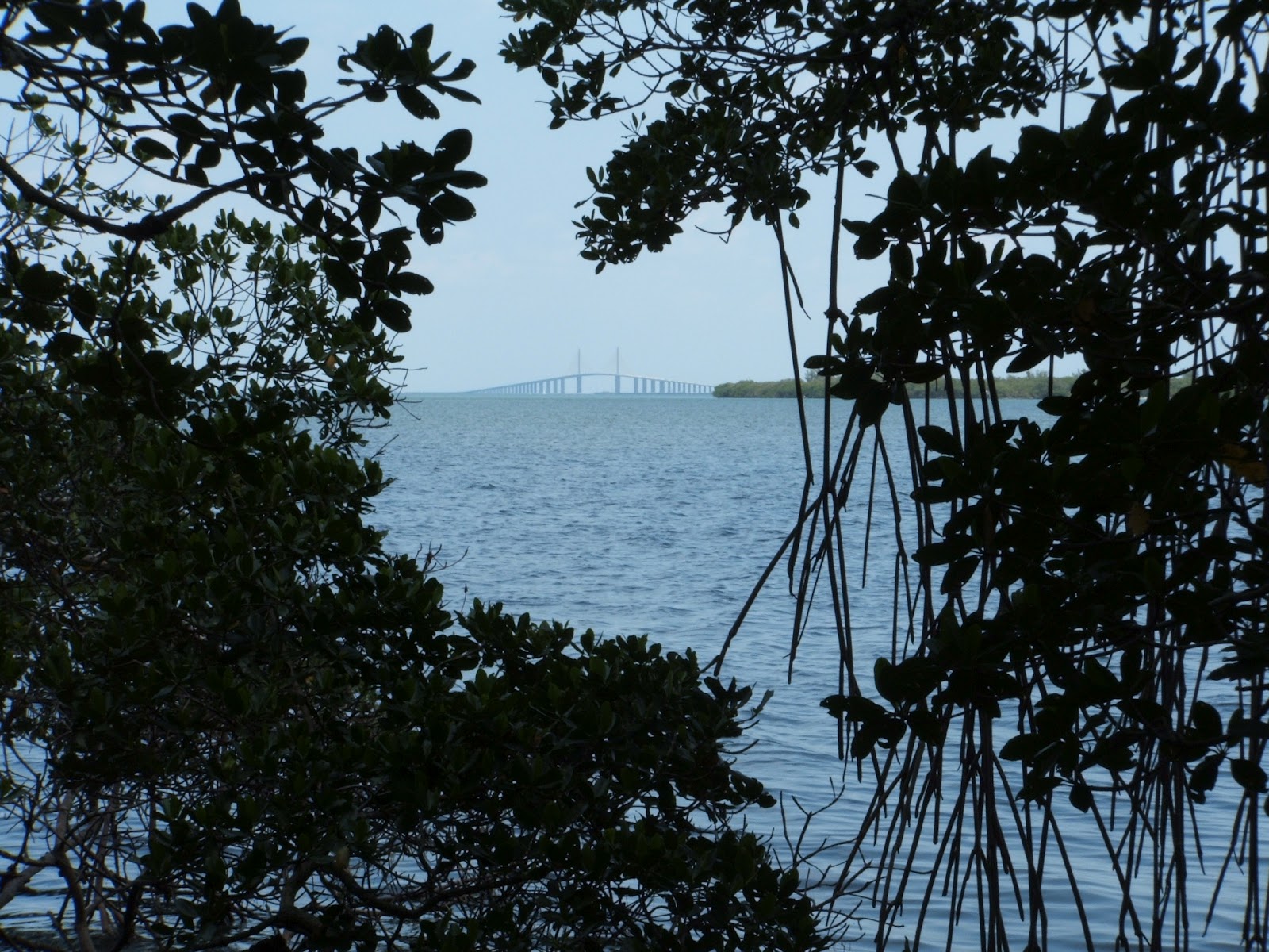
    Putting this exercise path 6 feet further to the right, away from the wave action zone, could have prevented this.. Cutting back the mangroves to "Improve" the view als limits the root growth that could have naturally stabilized this area.

Forethought in trail layout can allow a gentler slope, avoid  wave action zones, and make approaches to road or stream crossings safer.


Changing the route of a trail, once established, can be difficult. Doing it right the first time saves costs, and is obvious to experienced hikers. Fences, signs, and even tall boardwalks may have trouble re-routing hikers intent on following the "old" path.
  Nominated for an "Outstanding Boardwalk" Award from the William Greenfield Center for Environmental Stewardship, Sawgrass Lake Park Boardwalks are wide, well maintained, and ADA Compliant.

Trail width should allow two adult hikes to pass side by side. Boardwalks should allow two wheelchairs to pass side by side. Wider spots on the trail can allow groups to gather, like at a particular view or be used for a rest bench.


In archeological sites, and other sensitive areas, trails are often very narrow. Narrow trails concentrate all the foot traffic into one small tread area.


This often leads to a "Cow Path" effect. Dairy cattle walk one behind the other, and can cut deep into topsoil in a short time. Once established, the cows use the same narrow trampled surface, forming a trough that leads to erosion.
 
To avoid this, managers often use crushed rock or shell and put logs or landscape timbers on both sides of the trail. This slows or prevent erosion and helps delineate the permissible walking area.


Click a link  below, or copy and paste to your browser,  to go there!

A little bit of prose, some poetry, and a song- all about the environment.
http://billyholcoutdoors.blogspot.com/2012/05/whose-garden-was-this.html

A frank discussion about wilderness and nature.
http://wmgcenter.blogspot.com/2012/05/can-you-find-wilderness.html

Facebook pages about the outdoors.

Outdoor Photography

Hiking Trails, Boardwalks, and outdoor recreation construction topics
http://willwalkforfun.blogspot.com/

Friday, May 25, 2012

Steps on Trails WWFF-06


Stairs in general

Tread design and spacing on stairs are not only important to ascetics, but safety is paramount to anyone that must use the stairs.


The visibility of steps is critical to ensure that a person can prepare to coordinate their gait during stair ascent and decent. For people with normal vision this relies on visual clues such as handrails, depth perception and visibility of step nosing. Poor delineation of the step edge may confuse people negotiating the stairs increasing the risk of a miss step.


In the absence of contaminants on the stair tread, frictional factors play a minor role in stair safety during descent for interior stairs that are clean and dry. For outdoor stairs,  the slip resistance can be a significant factor and stair treads should be naturally course or treated with adhered grit. Composite lumber made from plastics can be very slippery when wet, even from dew.


Handrails provide a visual clue that there are steps present. Handrails reduce the risk of a miss-step by increasing postural stability and assisting as a fall restraint.


The dimensional geometry of stairs should establish a suitable gait pattern that is consistent throughout the flight of stairs. The dimensions of stair risers should be between 115 - 190 mm.  Stair steps should be greater than 300 mm as the risk of over stepping over the edge of the stair is significantly reduced. Dimensional inconsistency of stair steps and risers can have a tremendous impact on a person’s gait and balance, and are generally not visually obvious. Stairs with an irregularity as little as 6 mm between adjacent rise and runs can disrupt foot movements enough to cause a fall. A person has an expectation of a certain distance at which to place their foot at each step. If that expectation is not met, a fall can result from a misstep. This most often occurs when the stair step dimensions are reduced significantly near the bottom of stairs when the pedestrian has built a degree of confidence of where the next step will be to ensure proper safe foot placement.


Open steps with no vertical face allow for faster drying, and allow the wind to clear leaf litter and debris. They allow light through, but might make people that are wary of heights nervous and uncomfortable. Faced steps are more structurally sound, and usually show fewer effects from weathering. They also have less felt wind by the user.Although it adds cost and weight to a structure, enclosing the face of steps (vertically between the steps) can help with structural soundness, and with confidence in children and others nervous with heights.


Steps can limit the access to an area for people with mobility issues, and there is usually an alternate route offered with an inclined ramp or circuitous route.


Open tread “steps” within a trail are a cross between erosion control and a stair. They are an open top box, with board sides to prevent soil movement. They are not ADA friendly, but allow a foot path to climb quickly in a steep environment. They are longer laterally along the trail, but their open design allows more people on the structure at one time than a set of traditional stairs.


Ladders are typically used for service structures and egress. Once used for final climbs in structures like the Blackhawk Statue in Oregon Illinois and the Shark Valley Observation Tower in the Everglades, they are no longer used for liability reasons.


Transitions from boardwalk to trail may have steps, but more often the boardwalk is sloped down below the trail surface. The transition to asphalt or concrete trail surface from a boardwalk is usually a well-defined edge. Transition to dirt, gravel, or crushed shell trail surface requires the boardwalk to be angled in to a position well below the soil level to avoid guttering at the transition.

Trail Bridges WWFF-05


Trail Bridges

The longer a trail or boardwalk is, the higher the likelihood that it will need to cross a stream, street, highway, boulder field, or scree slide area.

    Crystal River Preserve fire road and trail cross the slow, low volume flow of Deer Creek.

 Smaller loads allow for simpler structures. Higher clearance requirements, higher moving “live” loads, or heaver traffic like ATV’s or service vehicles require more elaborate structures.


Water crossings typically call for a specifically designed structure based on water depth and speed, water volume including highest flood or tide considerations, and posted trail traffic type. A multi-use trail and fire road might only need a few metal or plastic culverts to cross a small season stream of low volume. Many boardwalks continue over small streams with no change in height, materiel, or bracing.

                               Floating dock at Mobbly Bayou Preserve in Oldsmar Florida

Transitions to a floating dock in tidal or seasonally changing water levels involve a “rolling bridge”.  This is fixed to the land side boardwalk with a hinged attachment flap that allows up and down axis movement. The bridge then touches on the free-floating dock with metal wheels on metal plates. The dock has caged piers or pilings that allow it to float up or down on the changing water level.  The dock can only go up or down, but not side to side. The bridge can change angle to match the dock height by rolling along the long axis of the dock.

                    Pinellas Trail crossing a surface street in Bellair.

Crosswalks are marked surface level crossings of streets, driveways, or other trail types. Signage to delineate the crossing, including trail marker blazings are typically present.  The higher the volume of traffic, the more elaborate and numerous the approaches, warning signage, pavement markings,and use restriction signs and devices become.
                             Steel trail overpass at a busy intersection. 
Small service vehicles and police motorcycles use this overpass as well as bicycles and foot traffic.

Busy streets and busy trails are best dealt with using trail overpasses. Although expensive, they save lives, do not interrupt traffic flow, and avoid signage costs.The higher clearance requirement, higher volume moving “live” loads, and heaver traffic like patrol or service specialty vehicles require this more elaborate structure. This metropolitan area is close to parks, beaches, and salt water estuaries that attract thousands of users a day. There is traffic to two mega-shopping areas  and a VA Hospital adjacent and a regional mall  and a marina nearby.  The county invested in this structure instead of a crosswalk. 


Tuesday, May 22, 2012

TRAIL FAIL WWFF-04


Trail Fail- Mobbly Bayou Wilderness Preserve.

The Preserve trails are a failure, and the plan that was so well written has not been pursued. 

From Pinellas County’s Website

“Located at the north end of Upper Tampa Bay, the preserve encompasses a wide diversity of upland and coastal plant communities. The 396-acre preserve is managed through an interlocal agreement with the city of Oldsmar, which is responsible for the management of two recreational areas. Land management activities at Mobbly Bayou Preserve are guided by the Mobbly Bayou Management Plan 2004. Upland, intertidal, and subtidal communities in the bayou have suffered significant environmental distress due to dense urbanization. Approximately 200 acres are targeted for restoration and enhancement of coastal communities using funds provided by the Southwest Florida Water Management District, Pinellas County and City of Oldsmar Parks and Recreation Department. Two major goals are to restore the hydrology of the bayou's tidal creek system and to enhance the degraded vegetation communities by removing exotic species and planting native species.”

The plan and the websites mention a hiking trail. 


                              The wide concrete exercise trail in Mobbly Bayou Preserve.

Inspection revealed a 12 foot wide concrete exercise path with one “workout station” near the picnic shelter. This large sidewalk was built along the active wave break zone and is undermined by water action and soil movement along its west side and at the end. It is Not a nature trail, and not even a hiking trail.

     Wash out and path damage. There is no railing despite a 5 foot drop to open water.

At two of the western side underminings, workers did not fill it with native soil or crushed shell, but rather stacked bags of concrete in the gap. Engineering a proper layout before construction, and moving it 6 feet east would have avoided this. The mangroves along the west side have been trimmed, ostensibly to improve the view the water. 

          End of the trail- not to a boardwalk or sunset view pavilion, but to…ooops!

The trail termini is located after a slight curve. The pavement is cracked and dangles over a five foot drop to the water below. There was no signage, barrier, nor cones to warn any one running on the exercise path. It  takes little imagination to envision a solid abutment, a transition to high boardwalk that goes out to the far end of the spoil island with a covered rest pavilion on pilings.

                                                     DEP funded “hiking trail”.
The  Department of Environmental Protection provided funding for an interconnection trail. What we found was a truck path to several dump sites. The “trail” was not blazed or marked, and several tire tracks lead off in different directions to dump sites used by the city.

 City dump site. A "mulch pile" would have chipped and shredded woody fiber, and would get turned like compost. One would have been bad enough, but there were 6 different dump sites...and  this is supposed to be a recreational trail.ugh. no, ugly!

The Preserve trails are a failure, and the plan that was so well written has not been pursued.

Mobbly Bayou Preserve has an on-line Restoration plan available at this link- http://www.pinellascounty.org/park/managedlands/pdf/MBP/MBP_Mgmt_Plan_2004.pdf